About Tide Now Chesapeake
Tide Now Chesapeake is a tide calculator for the Chesapeake Bay. It also covers the Delmarva peninsula Atlantic shore. The app breaks the area into 14 regions organized by the waterways. It includes 126 tide stations. The...
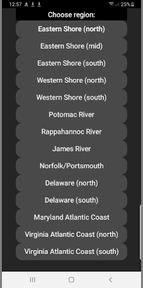
Tide Now Chesapeake is a tide calculator for the Chesapeake Bay. It also covers the Delmarva peninsula Atlantic shore. The app breaks the area into 14 regions organized by the waterways. It includes 126 tide stations.
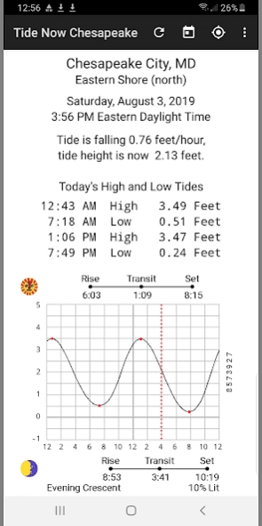
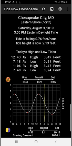
The app displays a tide graph, daily tide table, present tide status, and daylight/sun/moon timing.
Off Line Operation- app does not use the internet, it works by calculation.
Predictions are quick the app is simple to use. Use swipe gestures for the next and prior day tides. There are no ads and app cannot access phone features.
User Options
The action bar controls are Location, Date, and Refresh. The settings controls are Access Favorites, GMap Station (internet), Change Color Scheme, Sun and Moon Info, Mark Height, and About Gestures.
This app was written using well-known tidal prediction algorithms and publicly available location data. It matchs very closely to federally-published tide tables.
200 Year Calendar - In addition to today's tides, a date picker is available to choose any date from 1901 to 2100.
Next Day, Prior Day Swipes
Regions and their Tide Stations
Region Eastern Shore (north)
Chesapeake City, MD
Town Point Wharf, MD
Betterton, MD
Tolchester Beach, MD
Crumpton, MD
Love Point Pier, MD
Matapeake, MD
Kent Point, MD
Hillsboro, MD
St Michaels, MD
Region Eastern Shore (mid)
Easton Point, MD
Oxford, MD
Cambridge, MD
Beaverdam Creek, MD
Barren Island, MD
McCreadys Creek, MD
Bishops Head, MD
Crisfield, MD
Saxis, VA
Region Eastern Shore (south)
Shelltown, MD
Ape Hole Creek, MD
Guard Shore, VA
Schooner Bay, VA
Onancock, VA
Harborton, VA
Rappahannock Light, VA
Cape Charles Harbor USCG, VA
Fishermans Island, VA
Gaskins Point, VA
Kiptopeke, VA
Region Western Shore (north)
Havre de Grace, MD
Pond Point, Bush River, MD
Baltimore, Patapsco River, MD
Annapolis, MD
Long Beach, MD
Cove Point, MD
Lower Marlboro, Paxtuxent R. MD
Solomons Island, MD
Point Lookout, MD
Region Western Shore (south)
Sunnybank, VA
Fleet Point, VA
Deltaville, VA
Dixie, VA
Mobjack, VA
Belleville, VA
West Point, York River, VA
Cheatham Annex, York River, VA
Gloucester Point, VA
Messick Point, Back River, VA
Hampton, Old Fort Comfort, VA
Region Potomac River
Bladsenburg, MD
Washington, DC
Indian Head, MD
Quantico, VA
Dahlgren, VA
Colonial Beach, VA
Colton Point, MD
Piney Point, MD
Lewisetta, VA
Region Rappahannoc River
Massaponax, VA
Rappahannock Bend, VA
Tappahannock, VA
Wares Wharf, VA
Urbanna, VA
Millenbeck, VA
Windmill Point, VA
Region James River
Richmond River Locks, VA
Richmond Deepwater Terminal, VA
Puddledock, VA
Hopewell, VA
Wilcox Wharf, VA
Tettington, VA
Jamestown Wharf, VA
Scotland, VA
Kingsmill, VA
Fort Eustis, VA
Newport News, VA
Region Norfolk/Portsmouth
Western Branch Elizabeth River
Sewells Point, VA
Portsmouth, Norfolk Shipyard
Money Point, VA
Lafayette River, VA
Chesapeake Bay Bridge
Cape Henry, VA
Rudee Inlet, VA
Region Delaware (north)
Edgemoor
Wilmington Marine Terminal
Millside R.R. Bridge
New Castle
Delaware City
Pea Patch Island
Branch Channel Bridge
Reedy Point
Summit Bridge
Taylors Bridge
Region Delaware (south)
Woodland Beach
Leipsic, Leipsic River
Mahon River Entrance
Bowers Beach Murderkill River
Mispillion River Entrance
Ocean City Inlet
Ocean City Fishing Pier
South Point, Sinepuxent Neck
Buntings Bridge
Public Landing Chincoteague Bay
Snow Hill, Pocomoke River
Region Virginia Atlantic Coast (north)
Franklin City
Jesters Island, Chincoteague Bay
Chincoteague Island, Blake Cove
Chincoteague Island, Oyster Bay
Chincoteague Island, Lewis Creek
Chincoteague USCG Station
Chincoteague Channel, South End
Harbor of Refuge, Chincoteague
Wishart Point, Bogues Bay
Assateague Beach, Toms Cove
Wallops Island
Region Virginia Atlantic Coast (south)
Gargathy Neck
Folly Creek, Metompkin Inlet
Metompkin Inlet inside
Wachapreague
Revel Creek, Revel Island
Upshur Neck, south end
Great Machipongo Inlet inside
Sand Shoal Inlet USCG Station
Oyster Harbor
Smith Island USCG Station
Previous Versions
Here you can find the changelog of Tide Now Chesapeake since it was posted on our website on 2019-11-07 12:37:19.
The latest version is 3 and it was updated on 2024-04-22 14:03:34. See below the changes in each version.
Tide Now Chesapeake version 3
Updated At: 2023-10-17
Changes: Android 13 update
Tide Now Chesapeake version 2
Updated At: 2020-09-17
Changes: Tested with Android 10
Added military time format option
Added contact info
Added grid control
Added show station info
checked all stations
Tide Now Chesapeake version 1
Updated At: 2019-08-03
Changes: Initial Release August 2019